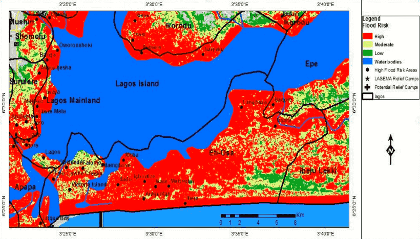
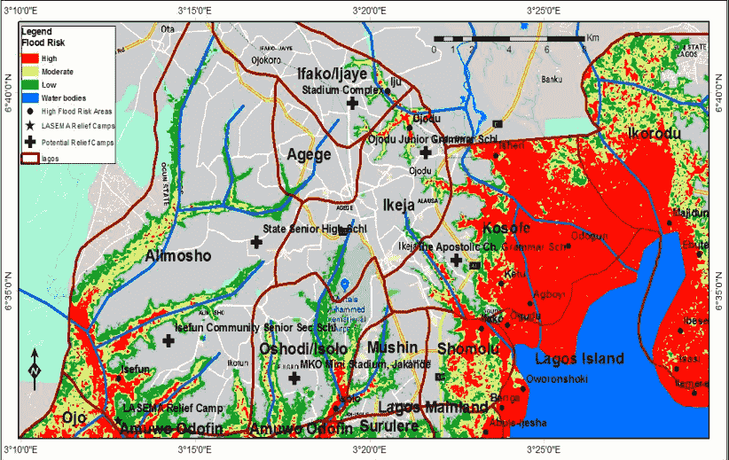
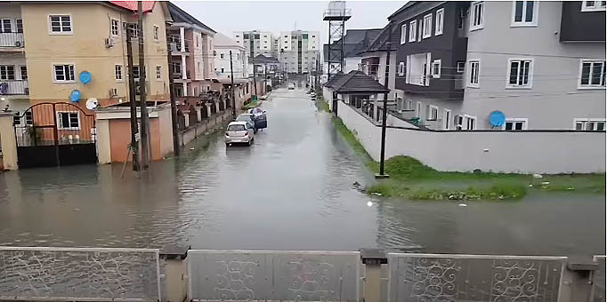
Most parts of the city of Lagos is surrounded by water. It’s therefore no surprise that the city is prone to flooding particularly during the rainy season. The Lagos state government , in an effort to reduce the impact of flood in the state, conducted a report to determine the most flood prone areas and least prone areas in the state.
The report, which was conducted by the Lagos state emergency management agency using integrated approach of remotely sensed data and geographic information system, shows the areas most susceptible to flooding and also shows the areas least prone to flooding in Lagos.
Local government areas at high risk of flood in Lagos
Eti-osa
Eti-osa has the largest percentage of land area at high risk of flood in the state. Etisa-osa has a total land area of 168.3km with 133.59km at high risk of flood.This means,79.38% of Eti-osa LGA’s land area is at high risk of flood. Popular cities in Eti-osa include Obalende, Victoria-island, Bamgbose, Ilado, Igboefon, Ikate, Alaguntan, Ibeju, Maiyegun, Ibeju, Langbasa, Iranla, Badore

Ajeromi/Ifeodun
66% of the total land area in Ajeromi/Ifeodun is at high risk of flood according to the report. With a total land area of 11.65Km , 7.76 km of its total land area is at high flood risk. Areas in Ajeromi/ifelodun include coker andayetoro
Apapa
The total land area in Apapa LGA is 32.9km and 19.9km of Apapa’s total land area at high flood risk. This means, 60.52% of Apapa’s tota and area is at high food risk. Cities in Apapa: Ijora, Ajegunle, Dankaka, Tincan Island, Igboejo, Tarqua bay
Amuwo-Odufin
54.35% of Amuwo-odofin’s total land area (173.38km) is at high food risk. Areas Amuwo-odofin; Ago palace, Agboju, Alapako, kirikiri, isuna, Igbalogun, inogbe, ibasha,imore, ilashe, ibeshe, Asogun,Irede, Ikare, ondotedo
Kosofe
With a total land area of 74.12km, 47.96% of kosofe local government area is high flood risk. Cities: isheri, odgun,ketu, Agboyi
Other local government areas in Lagos at high flood risk include
Ojo – 43.80% (Iba, ishahi, era, egan, eteggin, igbede,igbolobi, ishagira, Tafi)
Surulere – 39.16% (itire, ikate, lawanson, Ijeshatedo, Osho, Aganni)
Badagry- 37.63% (Magbon, Mowo, Gbanko, Moba, Ajara, Isalu, Panko, Agonrin, Wasere)
Lagos Mainland – 36.92% (Abule-Ijesha, Alagbede,Abulenla, Iganmu,Ijero)
Lagos Island- 35.4% (Iwaya, Makoko,Ebute-meta)
Ibeju-Lekki – 28.7% (Okunsola, kuramo island, Tiye, Mobido, Ebute-lekki)
Local government areas at low risk of flood in Lagos

The following local government areas in Lagos are not at risk of flooding.
Agege
Agege is the local government area in Lagos with the least flood risk. Agege has a total land area of 16.68km with 0% land area at high flood risk.
Ifako Ijaye
Next on the list of local government area at low risk of flood is Ifako ijaye with 0.54%. only 0.18km of its 33.63km total land area is at high flood risk
Ikeja
The seat of goverment in the state is also at low risk of flood, with just 1.84% of its total land area(45.74km) being at risk.
Mushin
With a total land area of 17.39km , only 0.5Km of Mushin’s total land area is at high flood risk. Percentage of land area at risk of flood in Mushin is 2.86%
Oshodi
Oshodi is also at low risk of Flood. 3.7% of Oshodi’s total land area (38.8Km), is at high flood risk.
Ikorodu
The ever growing city of Ikorodu is also at low risk of flood at 12.56%. With a total land area of 363.68km , 45.67km of the area is at high flood risk
Epe
Total land area-875.39km , Land area at high flood risk 143.42km , percentage of land area at high flood risk 16.39%
Areas to avoid during heavy downpour in Lagos
According to the office of the drainage services in Lagos, the following area should be avoided during raining season in Lagos.
- Ayobo, Aboru in Ipaja
- Bariga
- Anifowoshe, Ikeja
- Ijesha
- Meiran,
- Ajasa Command Road in Agbado-Okeodo
- Alagbole, Isheri in Berger area,
- Okun-Ajah, Lekki Peninsular
- Iyana-Ipaja
- Owode
- Badiya
- Aboru
- Iwaya
- Arowojobe in Maryland
- Ajegunle
- Elede
- Ajegunle
- Owode-Onirin
- Kuramo Beach
- Oke Afa, Ejigbo and Bucknor area in Ejigbo
- Maza Maza
- Ijegun Isheri
- Agbado
- Akute
- Ikoyi
- Victoria Island, Ahmadu Bello Way
Notable areas not prone to flooding in Lagos
Festac
Located along the Lagos-Badagry Expressway on Lagos mainland, FESTAC is reputed to have the best drainage system in Lagos. It’s therefore not a surprise that this area isn’t prone to flooding unlike other places in Lagos.
Ojodu (college road via ogba)
One of the most sort after places on the mainland due to its proximity to Ikeja. Ojodu is also one of the few areas not prone to flooding on the mainland.
Other areas include Akesan Lasu/isherri road, Awuse Estate, Ikosi-Ketu, Magodo, Muri okunola or Etim inyang crescent, Pedro palm grove, Gbagada

